Select Theme

  • Default Theme
  • Blue Theme

Text Size

  • Increase Text Size
  • Decrease Text Size
  • Normal Text Size

Current Size: 100%

Skip to main content

Screen Reader

Select Language

  • English
  • हिन्दी
  • ਪੰਜਾਬੀ
this is logo image

Main menu

  • Home
  • About Us
    • About the Department
    • Organization Brief / Structure
    • Agriculture Extension and Training
      • Agriculture Extension And Training
      • ATMA
      • Agriculture Information
    • Punjab Agriculture Council
    • Sugarcane
  • Acts / Orders
  • Crops
  • MSP
  • Publication
  • Institution
  • Gallery
    • Photo Gallery
    • Video Gallery
  • Schemes
  • Contact Us
  • Recruitments

Search form

Sidebar Menu

  • Agriculture Extension and Training
  • Plant Protection
  • E- agriservices
  • Agriculture Inputs
  • High Yielding Variety Programe
  • Seeds
  • Goverment Seed Farms
  • Cash crops
  • Cotton
  • Maize
  • Punjab State Council
  • OilSeed
  • Pulses
  • Agriculture Marketing
  • Agriculture Engineering Wing
  • Farm Mechanization
  • Hydrogeological Wing
  • Map
  • Agriculture statistics
  • Crop Cutting Experiments
  • Sugar Cane
  • Census
National Portal of IndiaDigital India
  1. Home
  2. Welcome To District Bathinda(Punjab)--Introduction
Welcome To District Bathinda(Punjab)--Introduction

bhatinda image

Bathinda is one of the historical and important towns of North India. It is associated with the imprisonment of Razia Sultan in the Fort, which is more than 1800 years old. It was also called Wahtinda and Bitunda which finally become known as Bhatinda. But its name was changed to Bathinda on the authority of Survey of India to conform to the phonetical expression as locally pronounced. Bathinda district is situated in the southern part of Punjab State in the heart of Malwa Region, and is located between 29°-33’ and 30°-36’ north latitude and between 74°-38’ and 75°-46’ east longitude on the globe.
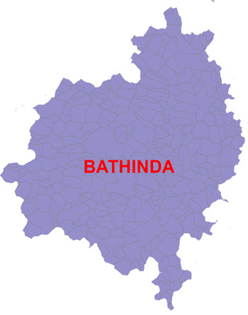
The district is surrounded with Sirsa district of Haryana state in the south, Barnala and Mansa district in the east, Moga in the north and Faridkot and Mukatsar in the north-west. The district has eight towns, namely Bathinda, Rampura Phul, Maur, Raman, Bhuchu, Goniana, Kotfateh and Sangat and one census town (Bhisiana). The distict has been divided into 3 sub-division at Bathinda, Talwandi Sabo and Phul, which are further sub-divided into 8 development blocks namely Bathinda, Sangat, Talwandi Sabo, Nathana, Rampura, Phul, Bhagta Bhai Ka and Maur. The district comprises of a total of 292 villages (includes 7 Municipal Councils Sangat, Raman mandi, Maur, Kotfatta, Rampura, Bhucho Mandi, Goniana and 1 Municipal Corporation Bathinda and 5 uninhabited villages) 305 Gram Panchayats and 9 Market Commitees operating in the district. The headquarters of the district are located at Bathinda.Map of district Bathinda is shown in figure 2.1.
General Statistics
1.Socio- Economic & Demographic Information Social and economic profile of households of different blocks in the district The data related to socio-economic and demographic features as given in the table 2.1.2.1 indicates that the total population of the district is 871652 as a whole. The Maur block has a minimum population i.e. 81782 whereas the maximum is accommodated in the Bathinda block which is 171499. This population is residing in 140380 houses out of which 50769 houses are occupied by scheduled castes and 51163 houses by landless labourers. The total farming families are 86167 and out of these 4860 farming families are marginal and small having less than 2 hectare land holding, which indicates the dire need for making efforts for cooperative farming to make agriculture a profitable venture.

AttachmentSize
PDF icon GENERAL DESCRIPTION OF THE DISTRICT74.25 KB
PDF icon District At A Glance76.45 KB
PDF icon Area Suffering From Low Yields Compared To Average Yield In The Gps10.87 KB
PDF icon Details Of Electricity Connections And Supply In Rural Area Of Different Blocks47.41 KB
PDF icon Development of Agriculture Sector153.71 KB
PDF icon District Income54.17 KB
PDF icon Education41.2 KB
PDF icon General Description Of The District74.25 KB
PDF icon Infrastructure Availability And Additionally Needed In Primary94.59 KB
PDF icon Intra-District Growth Differentials90 KB
PDF icon Irrigation And Ground Water371.02 KB
PDF icon Land Use Pattern And Land Holdings214.09 KB
PDF icon Public And Private Lands Under Problem In The Gps91.38 KB
PDF icon Sectoral Information47.03 KB
PDF icon Special Projects148.24 KB
PDF icon Topography And Agro Climatic Characteristics100.31 KB
PDF icon Contacts Details : CHIEF AGRICULTURE OFFICER Kheti Bhavan, ITI chowk, Dabwali Road, Bhatinda, Contact No:- 0164-224055830.04 KB
Last Updated: 21/10/2022 - 4:01pm

Footer Links

  • Copyright Policy
  • Hyper Linking Policy
  • Privacy Policy
  • Terms And Conditions
  • Disclaimer
  • Site map
  • Help
  • Accessibility Options
  • Feedback

Content available on the website is owned maintain by - Official Website Of Department Of Agriculture & Farmer Welfare, Government Of Punjab,India
Copyright © 2017-All Rights Reserved-Official Website of Department of Agriculture & Farmer Welfare,Government of Punjab,India

anadolu yakası escort bayan

escort bursa görükle escort bayan

bursa escort görükle escort

güvenilir bahis siteleri canlı bahis siteleri kaçak iddaa siteleri kaçak iddaa kaçak bahis siteleri perabet

görükle escort bursa eskort bayanlar bursa eskort bursa vip escort bursa elit escort escort vip escort alanya escort bayan antalya escort bayan bodrum escort

Valid CSS! WCAG -AA Valid XHTML 1.0 Transitional acheker