Select Theme

  • Default Theme
  • Blue Theme

Text Size

  • Increase Text Size
  • Decrease Text Size
  • Normal Text Size

Current Size: 100%

Skip to main content

Screen Reader

Select Language

  • English
  • हिन्दी
  • ਪੰਜਾਬੀ
this is logo image

Main menu

  • Home
  • About Us
    • About the Department
    • Organization Brief / Structure
    • Agriculture Extension and Training
      • Agriculture Extension And Training
      • ATMA
      • Agriculture Information
    • Punjab Agriculture Council
    • Sugarcane
  • Acts / Orders
  • Crops
  • MSP
  • Publication
  • Institution
  • Gallery
    • Photo Gallery
    • Video Gallery
  • Schemes
  • Contact Us
  • Recruitments

Search form

Sidebar Menu

  • Agriculture Extension and Training
  • Plant Protection
  • E- agriservices
  • Agriculture Inputs
  • High Yielding Variety Programe
  • Seeds
  • Goverment Seed Farms
  • Cash crops
  • Cotton
  • Maize
  • Punjab State Council
  • OilSeed
  • Pulses
  • Agriculture Marketing
  • Agriculture Engineering Wing
  • Farm Mechanization
  • Hydrogeological Wing
  • Map
  • Agriculture statistics
  • Crop Cutting Experiments
  • Sugar Cane
  • Census
National Portal of IndiaDigital India
  1. Home
  2. Welcome To District Gurdaspur(Punjab)--Introduction
Welcome To District Gurdaspur(Punjab)--Introduction

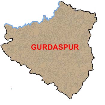
gurdaspur map image

The district comprising total geographical area of 3,56,000 hectares (7.1% of the state area) consists of 5 sub-divisions, 5 tehsils, 14 blocks (Fig.l) and 1642 villages. All the villages of the district are connected with roads to different towns and districts headquarter. The population of the district as per 2001 census is 21.04 Lakh (19.73% of the state); out of which 74.56 per cent is rural. Scheduled castes comprise 24.7 per cent of the total population of the district.Information regarding land utilization pattern and intensity given in table 1.The cropping intensity is lowest in Dhar block (158%) as compare to Kalanaur, Dera Baba Nanak & Bamial block where the intensity is (200%).
The month wise average normal rainfall is given in table 3. The lowest rainfall received during the month Nov and December, highest during June, July, and August. The block wise land holding along with area in thousand hectare block wise of different categories of the farmers i.e. marginal, small, semi medium, medium and large in given in table 4.The percent of marginal farmers are highest(27.68%) in Dhariwal block and lowest in Qadian (5.73%) where as small farmers highest in Gurdaspur block (28.52%),lowest in Qadian (15.49%),Semi medium, highest in Sri Hargobindpur block(41.17%) and lowest in Bamial (30.34%). Similarly medium categories of farmers are highest in Qadian (37.16%) & lowest in Bamial block (6.63%) . The highest irrigated area 90% by tubewells and lowest by the canal 1% is in Qadian block. Area production & average yield of rice is given in table 6, which is mostly sown in irrigated area except Dhar, Bamial, where (36-62%) area sown unirrigated conditions. The average yield is lowest in both the block. Highest yield is in Sri Hargobindpur is received i.e. 4064 kg/ha & lowest in Dhar kalan i.e. 2373 kg/ha. Similarly in table 7, ( 98% )area is sown in Dharkalan block unirrigated condition & DBN 100% areas sown in irrigated of maize crop, lowest yield is 2092 kg/ha in Dhar block & 4107 kg/ha in Kahnuwan, Where 29% is in irrigated condition. In case of Sugarcane 57% area is sown under rain fed condition, 100% area in DBN, FGC, Batala in irrigated, the average yield is lowest in Dhariwal block (5236 Qtl per hectare) where as Batala got 7488 qtl per hectare. In annexure table 9, wheat is cultivating in block Batala, FGC, Dera Baba Nanak, Dhariwal,under irrigated condition where as (89%) is sown in un irrigated condition in Dhar block , the lowest yield in Bamial 1814 kg/ha.

AttachmentSize
PDF icon Agro-Climatic Regions In District (This document is in English language)71.1 KB
PDF icon Status Of Major Crops In District (This document is in English language)51.38 KB
PDF icon Development Of Agriculture Sector (This document is in English language)59.29 KB
PDF icon General Information Of District Gurdaspur (This document is in English language)39.64 KB
PDF icon Land Utilization Statistics (Preceding 3 Years Average) (This document is in English language)164.23 KB
PDF icon Source Wise Area Irrigated (This document is in English language)19.26 KB
PDF icon Area, Production And Yield Of Major Crops (This document is in English language)474.63 KB
PDF icon Contacts Details:- CHIEF AGRICULTURE OFFICER CHIEF AGRI. OFFICER,GURDASPUR (This document is in English language)42.74 KB
Last Updated: 21/10/2022 - 4:01pm

Footer Links

  • Copyright Policy
  • Hyper Linking Policy
  • Privacy Policy
  • Terms And Conditions
  • Disclaimer
  • Site map
  • Help
  • Accessibility Options
  • Feedback

Content available on the website is owned maintain by - Official Website Of Department Of Agriculture & Farmer Welfare, Government Of Punjab,India
Copyright © 2017-All Rights Reserved-Official Website of Department of Agriculture & Farmer Welfare,Government of Punjab,India

anadolu yakası escort bayan

escort bursa görükle escort bayan

bursa escort görükle escort

güvenilir bahis siteleri canlı bahis siteleri kaçak iddaa siteleri kaçak iddaa kaçak bahis siteleri perabet

görükle escort bursa eskort bayanlar bursa eskort bursa vip escort bursa elit escort escort vip escort alanya escort bayan antalya escort bayan bodrum escort

Valid CSS! WCAG -AA Valid XHTML 1.0 Transitional acheker